
The question of whether a piece of land contains a viable aggregate resource is not answered by geology alone. A credible evaluation has to account for what is in the ground, whether that material can actually be mined, whether the surrounding market supports a new operation, and how a new entrant would compete with what is already there. That is the scope of a Burgex Mineral Resource Opportunity (MRO) study.
This article explains how we approach that evaluation: the data sources we use, the analytical steps we follow, and what clients receive at the end of the engagement.
What a Mineral Resource Opportunity Study Is
An MRO study is a systematic, data-driven evaluation of a land area’s potential as a commercial aggregate resource. It is used to answer a specific question: does this land represent a viable development opportunity, and if so, what would it take to pursue it?
The study integrates four distinct areas of analysis: physical and environmental screening, geological assessment, landholding and ownership analysis, and market context. Each component informs the others. A site with excellent geology and clean land title may still be marginal if the market is oversupplied. A site in a strong market may be disqualified by wetland constraints or a fragmented ownership structure that makes acquisition impractical. A complete evaluation requires all four lenses working together.
Physical and Environmental Screening
The first step is determining where on a study area mining is physically and legally feasible. No amount of geological potential justifies a site that cannot be permitted or operated.
Burgex integrates multiple GIS datasets to map features that constrain or exclude development:
- Wetlands and aquatic features. Areas mapped as jurisdictional wetlands or within stream buffers carry significant permitting complexity. We identify these features using National Wetlands Inventory data alongside local and state regulatory mapping, and we distinguish between features that may be mitigable and those that represent hard exclusions.
- Transportation infrastructure. Primary and secondary roads are both a constraint and a locational asset. We evaluate setback requirements from roadways and assess each site’s access to the transportation network that would carry aggregate to market.
- Railroads. Rail proximity is significant for two reasons: rail corridors carry setback requirements, and rail access can dramatically expand a site’s effective market reach. Both are mapped and evaluated.
- Utilities and infrastructure corridors. High-voltage electrical transmission lines, pipelines, and other infrastructure create setback zones that can remove large portions of an otherwise promising site from consideration.
The output of physical screening is a mapped picture of where within the study area development is plausible, and where it is not. This focuses the geological and landholding work on parcels that can actually be developed.
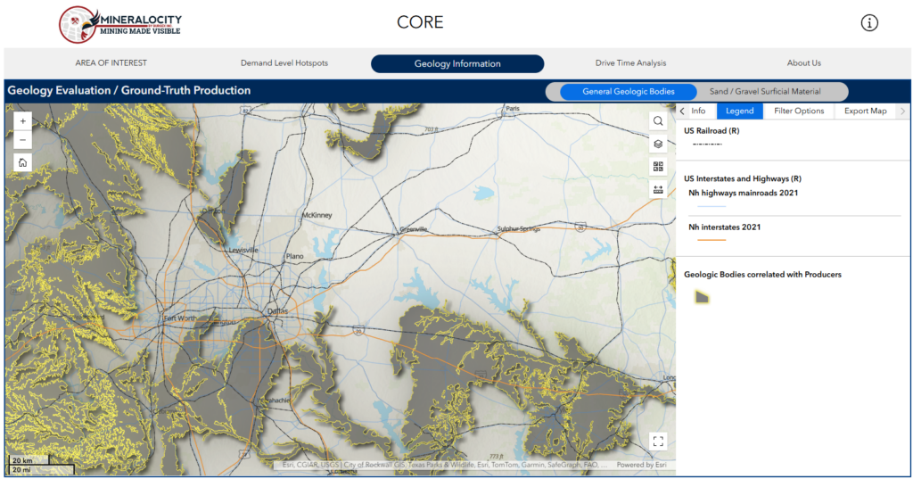
Geology bodies correlated with active producers, rail corridors, and highway infrastructure, as visualized through Mineralocity, Burgex’s proprietary aggregate intelligence platform.
Geological Assessment
With physically feasible areas identified, the next step is evaluating what is in the ground.
Burgex geologists assess existing geological data for the study area, including state geological survey maps, USGS publications, prior drilling or sampling records where available, and regional geological context. The goal at this stage is to identify areas where the geology is consistent with commercially viable aggregate production: appropriate rock type, likely deposit thickness, and absence of major structural complications that would affect mining.
For industrial minerals and aggregate specifically, geological assessment considers not just the presence of material but its likely quality. End-use requirements vary significantly by product type. Base stone, asphalt stone, commercial-grade crushed stone, and concrete aggregate each carry different specifications for hardness, gradation, and chemical composition. Where geological data supports it, Burgex evaluates whether the material present is likely to meet the quality thresholds that define commercial viability for the intended product types.
Geological assessment at the MRO stage is a desktop and remote-sensing exercise. It identifies where further investigation is warranted, not a reserve estimate or a confirmed mineral resource. Sites that pass geological screening are candidates for physical sampling, laboratory testing, and reserve estimation in a follow-on engagement.
Landholding and Ownership Analysis
A promising site with fragmented or inaccessible land title is not a viable development opportunity. Landholding analysis evaluates who owns what, whether surface and mineral rights are split, and how difficult or costly acquisition would be.
Burgex reviews parcel ownership data, mineral rights records, and existing encumbrances for the areas that pass physical and geological screening. We identify consolidated landholdings that could be acquired from a single owner, parcels where mineral rights have been severed from surface rights, and areas where existing leases or encumbrances would complicate acquisition. We also evaluate parcel size and configuration relative to the operational footprint a mining operation would require.
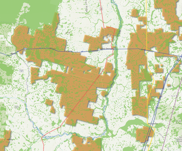
The output is a prioritized picture of land acquisition complexity. Some sites rank high on geology and market position but require assembling land from dozens of small landowners. Others offer a single large parcel with clean title. Both can be viable, but they carry different timelines, costs, and risks. Clients need to understand that distinction before committing resources to a site.
Market Context and Competitive Analysis
Geology and land access determine what a site can produce. Market conditions determine whether that production is worth pursuing.
Burgex evaluates the market environment surrounding each screened site using the same analytical tools that underpin our standalone aggregate market studies.
Supply analysis maps existing producers in relation to the subject site, using our proprietary Mineralocity platform for site-level competitive data across the United States. We identify who is operating in the relevant drive-time radius, what products they produce, their estimated scale, and how well-positioned they are to defend their market share against a new entrant. We also account for imported supply, aggregate transported by rail, river barge, or deep-water vessel from quarries outside the local area, which can represent a significant share of total supply in markets near major transportation corridors.
Gravity modeling is the core tool for supply analysis. Rather than simply mapping competitors within a fixed radius and applying a distance-based discount, our gravity model allocates each producer’s estimated tonnage to the specific demand nodes where we see consumption. This gives clients a spatially explicit picture of where existing producers are actually competitive, where gaps in coverage exist, and where a new operation would have genuine logistical advantages over the competition.
Demand analysis combines a per capita consumption model calibrated to the relevant USGS sub-region with forward-looking project pipeline data from Dodge Construction Network. The USGS sub-regional rate reflects meaningful differences in construction intensity and infrastructure investment patterns across geographies. The Dodge database captures aggregate-intensive projects from early planning through bid letting, categorized by type: wide-area infrastructure, local road and highway work, and nonresidential commercial and industrial construction. Together, these two inputs provide a current demand estimate and a view of how demand is likely to evolve.
Product-level analysis distinguishes between the different aggregate products a site might produce and the different markets those products serve. Base stone, asphalt stone, commercial-grade crushed stone, and sand and gravel serve different customers, carry different pricing, and face different competitive dynamics. A site well-positioned to supply asphalt producers may be less competitive in the ready-mix market. Understanding which product types the market needs, and which the site geology supports, is what allows a meaningful assessment of commercial viability.
Pricing intelligence rounds out the market picture. Burgex determines current market pricing through local market interviews, publicly available pricing indices, and other reliable data sources. Pricing is reported by product type and customer tier, reflecting the reality that large infrastructure contractors negotiate differently than commercial builders. This gives clients a realistic revenue assumption for preliminary financial modeling.
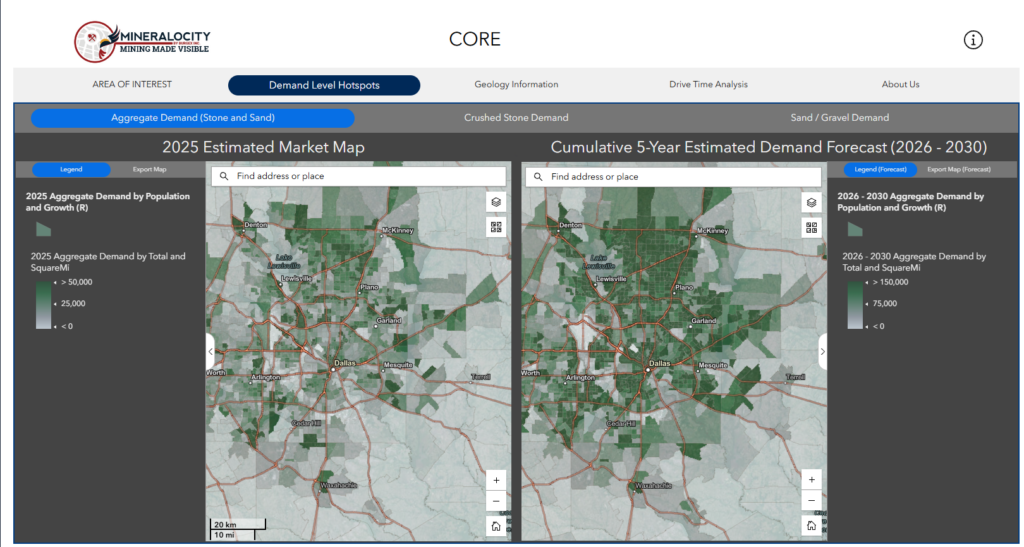
Current aggregate demand alongside a five-year cumulative forecast for the Dallas-Fort Worth market, mapped by census tract using Burgex demand modeling integrated with population growth and construction activity data.
How the Pieces Fit Together
The value of an MRO study is not in any single component. It is in how the components interact.
Physical screening identifies where mining is feasible. Geological assessment identifies where material quality and deposit characteristics support commercial production. Landholding analysis identifies where acquisition is practical. Market analysis identifies where demand and competitive conditions justify investment. A site has to clear all four screens to represent a genuine opportunity.
In practice, most study areas contain a range of outcomes. Some parcels screen out on environmental grounds. Others show promising geology but sit in oversupplied markets. A few combine the right physical characteristics, geological potential, accessible land, and favorable market position. Those are the sites an MRO study is designed to find.
What the Output Looks Like
Burgex delivers MRO study findings in two formats.
The first is a written report presenting the methodology, data sources, and findings for each component of the analysis, along with a prioritized assessment of the sites or parcels that represent the strongest development candidates. The report documents the basis for each screening decision so clients can understand not just which sites ranked highest, but why.
The second is an interactive ArcGIS Online map that integrates all of the study’s spatial data into a single platform. Clients can explore producer locations, geological features, parcel boundaries, demand concentration, infrastructure access, and screening results geographically rather than reading static maps in a PDF. This format is particularly useful for communicating findings to investors, partners, or internal stakeholders who need to understand the spatial context of the opportunity.
What an MRO Study Is and Isn’t
A Burgex Mineral Resource Opportunity study is a systematic screening and prioritization exercise. It identifies where development opportunities are most likely to exist and provides the analytical foundation for deciding where to commit resources to further investigation.
It is not a mineral reserve estimate, a feasibility study, or a permitting evaluation. Confirmed reserve estimates require physical drilling, sampling, and laboratory testing. Feasibility requires engineering analysis of processing, infrastructure, and operations. Permitting depends on regulatory review that no desktop study can predict. An MRO study tells you where those next steps are worth taking, not what their outcome will be.
What it does provide is a credible, data-driven basis for prioritizing development activity. For a landowner evaluating whether a property is worth pursuing, an investor screening a portfolio of sites, a producer considering where to expand, or a private equity firm evaluating an acquisition, the MRO study is the analytical starting point that focuses resources on the opportunities most likely to yield results.
Burgex Mining Consultants has conducted mineral resource opportunity studies across the United States for landowners, producers, investors, and developers for over 15 years. Our work combines proprietary data, rigorous GIS methodology, and deep hands-on experience in the construction aggregates industry.