
In the construction aggregate industry, evaluating potential greenfield quarry sites, analyzing regional supply deficits, and forecasting market demand require rapid, spatial decision-making. For decades, the standard deliverable from consultants for aggregate market analysis was a static PDF report—a dense document containing snapshot maps, static tables, and frozen data points that were out of date nearly as soon as the ink dried.
At Burgex Mining Consultants, we have shifted the paradigm away from static, bound reports toward dynamic, interactive geospatial tools. By leveraging interactive web applications, presentation-ready StoryMaps, and customizable spatial layers, Burgex provides clients with living market intelligence that directly plugs into their broader corporate strategy.
The Key Advantages of Digital GIS Deliverables
1. Presentation-Ready StoryMaps and Web Apps
Rather than forcing executive teams, board members, or local planning boards to flip through dozens of static report pages, Burgex delivers market studies as interactive ArcGIS StoryMaps and dedicated web applications.
- Interactive Narrative: Combine narrative text, geological surveys, infrastructure spending models, and live web maps into a single cohesive story.
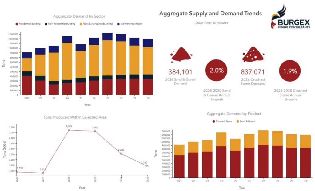
- Executive Impact: Stakeholders can immediately toggle layers—such as competitor locations, estimated annual production, haul radiuses, and population growth zones—to answer questions in real time during board presentations or investor pitches. Click on features to drill down on real data, or zoom out got get your bearings and understand the big picture.
2. Long-Term Value in “Living Data”
A static PDF is a snapshot of a single point in time. In contrast, an ArcGIS web deliverable represents living data.
- Continuous Updates: As regional infrastructure projects are announced, population forecasts shift, or competitor permits are updated, the underlying spatial datasets can be updated without requiring a complete rewrite of the report.
- Future-Proof Asset: Your market analysis grows alongside your operational strategy, serving as a reliable foundation for long-term market mapping, M&A due diligence, and capital planning
3. Interoperability Across Corporate GIS Platforms
One of the greatest limitations of traditional market studies is data isolation. When market intelligence is locked inside a PDF table or a flat JPEG map, integrating it with your internal operations requires tedious manual re-entry.
- Seamless Integration: Burgex delivers specific, feature-rich spatial layers (e.g., localized demand heat maps, site feasibility scores, transport networks) that your team can directly ingest into your company’s existing GIS platforms (such as ArcGIS, QGIS, or internal web dashboards).
- Cross-Departmental Utility: Land managers, mine planners, and executive teams can overlay Burgex market layers onto their internal maps to run secondary analyses.
4. Faster Turnarounds and Greater Client Control
Moving away from rigid document formatting accelerates turnaround times.
- Rapid Prototyping: By building on web platforms, Burgex consultants can compile, structure, and visualize geospatial data rapidly, delivering actionable insights in less time compared to traditional reports.
- Collaborative Cadence Calls: During routine project update calls, clients do not just hear about progress—they see the live web applications as they are actively being built and refined.
- Agile Iteration: If a cadence call reveals a need to test a new market boundary, adjust a haul distance radius, or filter by specific DOT aggregate specifications, Burgex can adjust map parameters to ensure the end deliverable aligns precisely with your strategic goals.
Comparing the Approaches
| Feature / Capability | Traditional PDF Market Report | Burgex Digital ArcGIS Environment |
| Data Format | Static, frozen PDF text and JPEG imagery | Live, interactive web maps and spatial feature layers |
| Deliverable Style | Flat document requiring manual review | Interactive StoryMaps & custom web apps |
| Data Updates | Requires purchasing a brand-new study | Continuous updates to living datasets |
| GIS Integration | Data locked in tables; manual re-keying required | Direct export/import of layer files into internal enterprise GIS platforms |
| Client Input | Review happens at the end of the project cycle | Live collaboration and layer adjustments during project cadence calls |
| Turnaround Time | Slower due to static formatting cycles | Faster delivery through agile web-based workflows |
Delivering Exact Results for Strategic Growth
By combining deep crushed stone industry knowledge with modern geospatial technology, Burgex Mining Consultants ensures you receive more than just answers to today’s questions. You gain an active digital tool designed to empower your team, streamline internal workflows, and give you a distinct edge in crushed stone market expansion.